The paper of Assoc. Prof. Takeshi Tsuji (CO2 Storage Research Division, I2CNER) was published in “Geophysical Journal International“.
■ Summary
For monitoring of the injected CO2, we use information of seismic velocity. By developing a new advanced method of Waveform tomography, we successfully estimate the very deep seismic velocity structures with high resolution. By applying this method to the seismogenic fault in the Nankai Trough, seismic velocity structure has been resolved in deep earthquake faults. The resulting velocity structures include low-velocity zones and thrust structures which have not been previously identified clearly.

Figure 1. Maps of southwest Japan and the Nankai Trough with sea bathymetry. An ocean bottom seismograph (OBS) survey was conducted in 2004 (solid black line). Circles indicate OBS positions; red circles indicate OBS positions used for waveform tomography in this paper. The 3-D reflection survey area used by Moore et al. (2009) is shown as a grey-shaded area. Dark blue contours show the coseismic slip distribution of the 1944 Tonankai earthquake (Kikuchi et al. 2003). The large arrow indicates the subduction direction of the Philippine Sea Plate (DeMets et al. 2010).
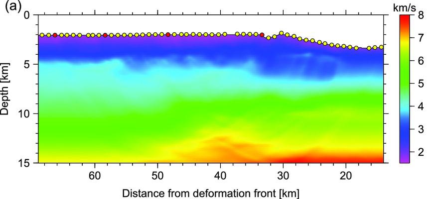
Figure 2. (a) Traveltime tomography result of Nakanishi et al. (2008), also used as a starting model for our waveform inversion.

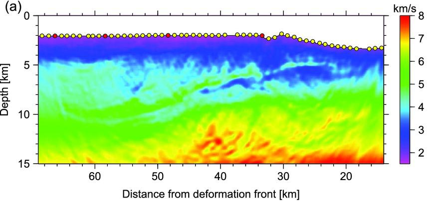
Figure 3. P-wave velocity structure after Stage 2 of waveform inversion. (a) Vp model.
■ Paper
Title: On acoustic waveform tomography of wide-angle OBS data-strategies for pre-conditioning and inversion
Authors: R. Kamei, R.G. Pratt and T. Tsuji
DOI: 10.1093/gji/ggt165
Publication Date (Online): May 22, 2013